Kirsten spent ages cutting together this video of the first six months of our travels. Enjoy! Note: If this doesn't work, use the lower quality version embedded below.
LATEST:
1625 GMT 10th September
Thursday, January 29, 2009
The Movie - Part 1
Labels:
Baltics,
China,
Diving,
Former Yugoslavia,
Indonesia,
Japan,
Micronesia,
Mongolia,
Philippines,
Poland,
Russia,
Trans-Siberian,
Video
Monday, January 26, 2009
Abel Tasman

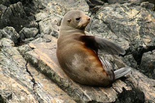
Another couple of hours up the east coast and we arrived in the small town of Kaikoura, mecca for whale watching. Our budget wouldn't stretch to getting in another plane and flying over the ocean trying to spot whales. However the seals and penguins that lounge on the rocks below the peninsular cliffs are free.

Our final port of call on the south island was the stunning Abel Tasman national park, on the north coast. On route we had time to call in at the Omaka Aerodrome near Blenheim. This is an impressive collection of (mainly full scale reproduction) WWI fighter planes, presented in sets built by Weta Workshop (of LOTR fame). Even if you don't have a nerdy fascination with old planes (and I don't), it's still well worth an hour if you're passing by.

This being a warm, long weekend, accommodation was thin on the ground, and we had to settle for two nights in a backpackers in Motueka, rather than more picturesque Marahau, further along the coast.

The two activities around here are hiking and kayaking. We opted for a full days kayaking, and were loaded onto the water taxi for the ride up to Onetahuti Beach. It's fairly busy in the park with over a dozen boat loads of kayakers leaving from the boat ramp in Marahau.
 We paddled out and around the seal colony on Tonga Island, before heading over to Bark Bay for lunch and a quick swim. We continued at a gentle pace to our final destination of Anchorage in Torrent Bay. Here dozens of kayaks are parked up on the beautiful beach, awaiting transportation back to base.
We had an afternoon crossing to Wellington from Picton, and as we approached along the ridiculously windy Queen Charlotte Drive, the weather worsened and the wind picked up. It was far too cold and windy to stand outside and view Queen Charlotte Sound pass by. So instead we sat inside in the upper foreword bar.

As soon as we cleared the Sound for the open waters of the Cook Strait, the ship started to get tossed by the mountainous sea. Thirty minutes later and the crew were busily running round with sick bags and paper towels. I seemed to be the only one still buying beer from the bar.

Sunday, January 25, 2009
Franz to Christchurch

Our next target was the pancake rocks in Punakaiki, a little way north of Greymouth. We'd decided to spend the night here (many people just pop in on their way along the west coast), in a nice enough backpackers on the beach – our room, which was a shed like annex to the main building was practically touching the sand.
 The pancake rocks are limestone pinnacles that formed in distinct 6 inch layers (apparently for reasons unknown), that look not unlike a large stack of pancakes. Amongst the rocks are a couple of blowholes, that fire up large plumes of spry during high tides and heavy swells. Unfortunately during our first visit, a few hours hours before high tide, they were putting on a bit of a lacklustre performance.
The plan for the next day was to drop back down to Greymouth, then cross over to Christchurch on the East coast via Arthur's Pass. Before leaving Punakaiki we revisited the blowholes, which, given the high tide and heavier seas, where putting on more of a performance.
 Arthur's Pass is another hiking centre, with many single and multi-day walks starting, finishing or passing through. Given our time constant, we took the easy 1 hour walk to the attractive Devil's Punchbowl waterfall, before continuing on to Christchurch.
As you drop down from the hills to the flat land west of Christchurch, the land becomes more parched and the thermometer starts to rise, reaching 35ºC before dropping back as you near the coast.
 Christchurch is a city of some 344,000 souls, and architecturally it differs from other New Zealand cities in its lack of wooden buildings. In fact, in size and appearance, it's not dissimilar to Cardiff. So 24 hours in Christchurch – we had a mediocre meal, then found a bar knocking out indie classics . The next day (after moving the car) we did the circuit on the tram, took in an art gallery, then entered tourist hell as we were punted round the Avon.
Friday, January 23, 2009
Fox and Franz Glaciers

In order to split up the long journey from Mount Cook to Fox we overnighted in Wanaka (Mount Cook to Fox took 10 minutes in a plane. Honestly, these Kiwis need to start digging some road tunnels). Wanaka is a big centre for hiking (or tramping as they prefer to call it), and for this reason we called in at Puzzling World on our way out of town, for a couple of hours of getting lost in a maze, and feeling very disorientated in the various illusion rooms.

I'd booked us in for a full day's walk on Fox Glacier. Tempted as I was by the Helihike option, you have to draw the line somewhere. So after being issued with sturdy leather boots, we boarded the bus to the access car park. It takes about an hour and a half to walk across the terminal moraine, then up through the bush on the side of the glacier, before one is finally issued with crampons for the ice walk.

A set of stairs has been cut in the steep side of the glacier, giving you easy access onto the top surface. Every morning a couple of the guides come down early to recut the steps on the constantly moving (and melting) ice flow. Given that it's about 16°C at the glacier base, it's melting fast, so there are many melt water steams and quite a few deep ponds.
 We soon moved beyond the pristine ice steps, and our guide hacked out rudimentary steps with his large pick, as we followed behind, occasionally getting sprayed with ice debris. The surface is a mishmash of crevices, and progress is fairly slow as you pick your way up and down. We lunched on the ice, before continuing our journey, stopping at a large ice tunnel. Here a rope was attached to a ice hock, and we took it in turns to lower ourselves in. Three hours later and we returned to more permanent ground.
We spend a second night in Fox Village, before making the short journey up to Franz Joseph Glacier. There are a number of walking options from the carpark, and we took the shortest. Franz is steeper than Fox, making its appearance from a distance more impressive, as it slithers down the valley. The warning signs at the glaciers are only too germane, as only couple of weeks ago two Australian tourists were killed after they walked right up to the terminal face of Franz, shorty before 20 tons of ice fell on them.

Thursday, January 22, 2009
Mount Cook


A change of wet clothes for Rich and quick coffee at the bungy place, and we were off for a spectacular drive through the desolate rolling brown hills of Central Otago, past the iridescent blue of Lake Pukaki and finally snow capped peaks and glaciers of the Southern Alps, we arrived in Mount Cook Village.

After finding our lodge, which doesn't take long as it is a tiny place really just set up as a base for tourists, we set out on the 3 hour hour round trip to the Hooker Lake and Glacier. We checked we were on the right path with some trampers in the car park who helpfully pointed out a good point about 30 minutes into the walk where they got views of Mount Cook. We couldn't see a thing when we go there except clouds, in fact we weren't even entirely sure which way to look. However, after another an hour or so walking, across a couple of rope bridges over roaring glacier run-off rivers the valley opened up and the clouds cleared to reveal a great view of the 3755m beauty. Just time for a couple of photos and the clouds descended again. The fun wasn't over though as this was our first chance to examine a glacier at reasonable close quarters and the terminal lake had a good number of large icebergs floating around.

The next morning we woke to bright clear skies and a perfect view of Mount Cook from the balcony of our lodge – honestly you wouldn't have know it was there the day before. We breathed a sigh of relief as we had booked in for the 8:30am scenic flight. When I saw the size of our plane however my relief turned briefly to panic. This was further exacerbated when the pilot cheerfully told us that it might be rather bumpy. The plan was to fly over The Divide, the mountains separating the Mount Cook area from the West Coast, so that we could see the Franz Joseph and Fox Glaciers. However, as there was a strong south westerly wind we were told it might be to bumpy so we would have to go up and see how it went.
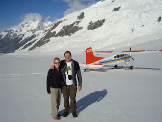
Our luck was in and not only did we have the whole plane to ourselves (apparently you could squeeze in five passengers), but the wind turned out to be not as bad as expected allowing us to complete the planned route. After I had controlled my initial terror, helped by taking an excessive number of photos, it was a really incredible experience. The views of the mountains and glaciers are spectacular and you can see every feature so clearer – a veritable geology 101.

After circling over the top of the Tasmin Glacier three times, each at a slightly lower altitude, to check if the snow was not too wet for landing we finally touched down – a pretty surreal experience seeing the mountains fly past as the plane comes to a surprisingly gentle landing on skis. Ten minutes or so on the ice gives you a chance to marvel at your surrounding and take yet more photos before you point the plane down the glacier and hope it takes off again.

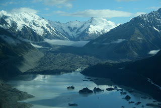
The rest of the day couldn't possibly live up to the excitement of the start but we had a pleasant enough drive past yet another stunning blue lake, Lake Tekapo and then on to Wanaka. For anyone who is interested, and hasn't already read the section in the lonely planet, the lakes in this area get their bright turquoise colour from sediment in the water which was created when the lake's basin was gouged out by a glacier. The milky quality that this gives the water refracts the sunlight creating the brilliant colour.
Monday, January 19, 2009
Milford Sound

Having a bloody big mountain range running the length of the south island does make crossing from east to west a right royal pain in the arse. Despite Queenstown being only 30 odd miles from Milford, the road takes a huge loop to the south, making the journey 4 hours if you floor it.

We decided to spend two nights in Te Anau, the last town before Milford, and still 90 minutes of belting round twisting roads. We'd booked a morning cruise on the sound, and hit the road before the convoys of coaches from Queenstown started clogging up the road.
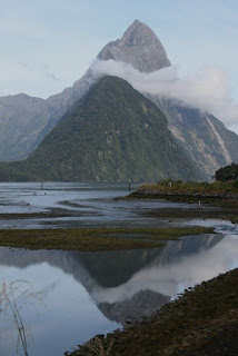 The temperature in Central Otago was 31°C, but this dropped to a rather more chilly 16°C as we approached the west coast. Still, given that Milford gets 7m of annual rainfall over more than 200 days, we were glad of a dry, if overcast day.
We'd opted for the two hour cruise out to the Tasmin Sea and back. Before we set sail the open top deck filled up to standing room only. As soon as the wind chill kicked in, most people bailed for the warm inside. We stuck it out, to photo the mountains rising almost vertically from the waters. The sheer size of the sound only becomes truly apparent when one of the light aircrafts takes off from Milford airport – the planes rise into the sky and then become specks against the towering mountains.
The huge amount of runoff causes a permanent freshwater surface layer, with the dark saline layer starting several metres down. This makes for some interesting diving in the fjords, with deep sea species making them their home. The thought of diving in X°C water did not appeal, however there is an underwater observatory which offers views 5m below the surface. We didn't see anything particularly big and ugly, but it's an interesting enough stop on the return leg.
We returned to Arrowtown in time to celibate Heidi's birthday in the Blue Door. Then next day we'd booked in for some horse riding along the Dart river from Glenorcy. My horse, Brain, was by far the fattest in the paddock, and refused all my attempts to get him to go faster than a trot. Kirsten's, Luke, sounded like Darth Vader. We spent two hours criss-crossing rivers and admiring the beautiful scenery. Mt. Alfred, which sits between the Dart and Rees rivers, is bigger than Ben Nevis, but is dwarfed by the surrounding mountain.

So it was time to say goodbye to Arrowtown and Janice's hospitality. However, we did make a quick stop for me to jump off a bridge.

Saturday, January 17, 2009
The Wop Wops

Heidi lives in what she describes as the Wop Wops – New Zealand rural backwaters, and the first inhabited place on our travels without mobile phone reception (although they do have broadband). Heidi's husband is New Zealand's foremost realist painter, Grahame Sydney. They share their house, and its stunning views, with wire haired terrier, Milo.

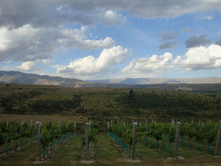
Whist not quite the Good Life, they do keep four chickens, a large vegetable patch, and best of all, they've planted a small vineyard that produced ten cases of Riesling even before reaching maturity. The jacuzzi sits amongst the lavender, so our early morning dip had a rather a pleasant aroma, as well as a great view.

Heidi and Grahame live on Cambrian Road, so called because Welsh prospectors dug for gold in the valley in the 19th century. We took Milo for a walk up the road, meeting the neighbours and marvelling at the home of the local eccentric, complete with tattered Welsh flag.

After lunch we took the two kayaks to the lake at St Bathans. This was once a hill, rich in gold seams, but decades of really hard work turned it into a large hole. The afternoon was spent paddling on the rather cold lake, before decamping to the local pub, the Vulcan. This is New Zealand's oldest working pub, complete with ghost and rather curious hole in the wall above the bar. The bar sport for the last 100 years or so, has been to climb up and squeeze through the hole, then avoid falling face first onto the bar. We got Heidi through first, followed by Kirsten, and finally some (skinny) bloke in the bar. There was no chance of my shoulders making through the hole, which is all very well, as the wall looked ready to collapse.

I took one of Grahame's bikes out for a quick 26km spin around the local dirt tracks after breakfast. After a long slog, I was glad to get the the steep descent into St. Bathans for a quick pint in the Vulcan. Then it was time to leave the Wop Wops for the long drive over to Te Anau. There was barely time to call in at the Carrick winery for some tasting.
Wednesday, January 14, 2009
Queenstown

Three hours and two short flights on from Napier we arrived in Queenstown, our first port of call on the South Island. The flight in was pretty spectacular with great views of the Southern Alps. The airport in Queenstown has a stunning location with a backdrop of the jagged Remarkables mountain range. It's then not long before you get a a glimpse of the crystal clear blue waters of Lake Wakatipu.
 We were met at the airport by the next on our list of McLeods, my cousin Heidi and aunt Janice and there two adorable wire-haired fox terriers Milo and Muffy. We were to by staying at Janice's place in Arrowtown, a short drive away from Queenstown, so we headed straight there.
Arrowtown is a very quaint old prospecting town, with many of the original wooden and stone buildings remaining form its heyday, after the discovery of gold in the Arrow River in the 1860s. It is now packed with excellent restaurants, boutique shops and art galleries. A veritable Marylebone High Street but with a back drop of stunning mountains.

After a lazy brunch in Arrowtow, we drifted into Queenstown for a look around, and to buy Rich some new hiking boots. Queenstown could easily be described as the the outdoor activity and adrenaline sport capital of the world. You name it, you can do it here. Soon you are overwhelmed by the weight of the leaflets you've picked up describing the different things you can jump off, swing from or speed down. The only problem is deciding what to do and how far you budget will stretch. Given that it was a beautiful day, we went for the jumping off the peak overlooking Queenstown with a bloke and a parachute attached option – i.e. paragliding. Despite being assured that this really was an activity any wimp could do, my fear of heights did start to get the better of me when instructed to run off the edge of the mountain. However, as at this point you are strapped to a large Kiwi bloke, you don't actually get much choice. Soon we were gliding over the pine forest towards the lake and it was totally worth it.

In the evening we opted for a more relaxing activity – catching a film at the charming boutique cinema, Dorothy Browns, in Arrowtown. Given it is to be our next destination, we watched Australia. I enjoyed it; Richard hated it. However, the bottle of wine and cheese board that we consumed during the film pleased us both.

Our next stop was to be my cousin Heidi's place in Central Otago. The drive there, through the Kkawarau Gorge, is very attractive with several places to stop along the way. First we watched several Bristish tourists taking the leap off the restored 1880s Kawarau Bridge at the worlds's first commercial bungy site. Watching a very green looking girl chicken out of the jump confirmed my conviction not to give it a go.
 It was then on to the Gibbston Valley wine region, where the speciality is the Pinot Noir. We stopped for a pleasant lunch at the Gibbston Valley winery and then on to do a spot of tasting at Peregrine. The final stop was for a quick photo next to New Zealand's tackiest monument – a giant fruit bowl in Cromwell – it must have been a tough competition between this and the giant carrot.
Subscribe to:
Comments (Atom)
